PLEASE ORDER YOURS NOW IF YOU NEED IT SOON. Supply chain issues are affecting almost every manufacturer. We will completely sell out of many items this season. Web site is updated at least twice daily on weekdays.
No risk to you. Your 100% Satisfaction is Guaranteed with our 30 Day "No Questions" Money Back Guarantee. Hassle-free returns & exchanges.
Not compatible with the Alpha 200i handheld.
Includes a redemption code for one year of FREE Hunt Chip map updates and one year of FREE access to any single state on the ONX Hunt App!
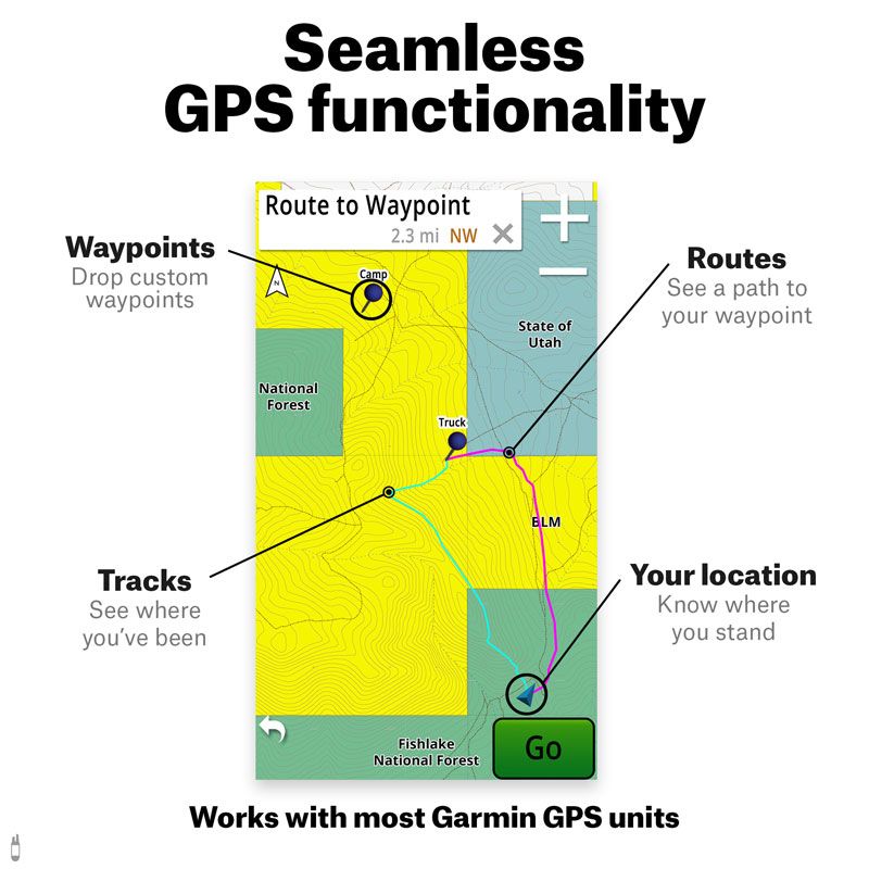
Use the ONX Hunt App to transform your smartphone or tablet into a powerful field-use GPS with no cell service required.
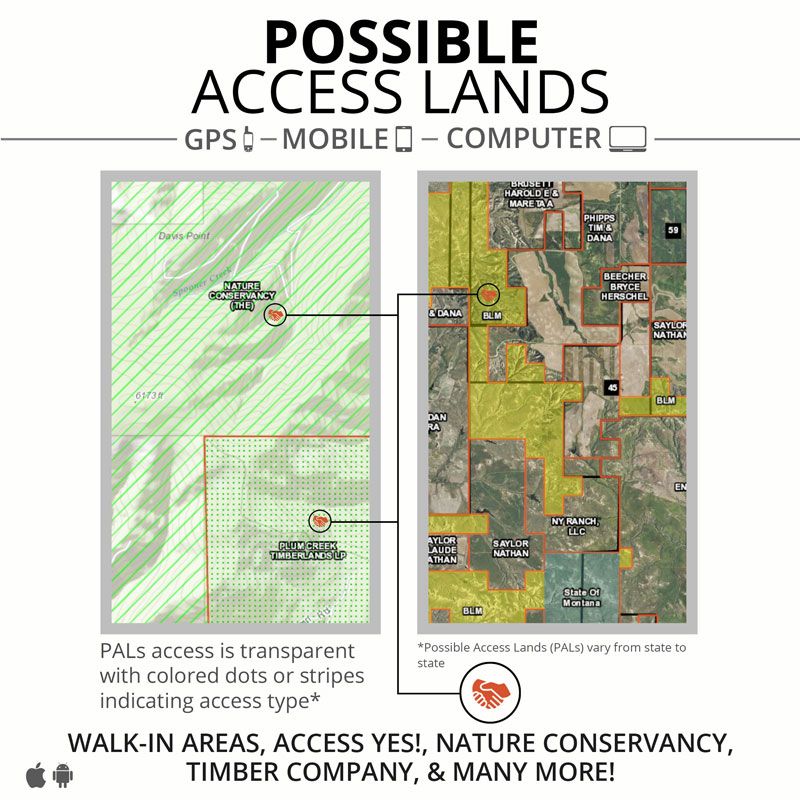
ONXMAPS HUNT Maps Overview
Private Land Ownership -- Names and Property Boundaries so you can request access
Color-coded Public Lands -- Federal (National Forest Service, BLM, etc.), State, Local, County Open Spaces, City Parks
Private Land Open to Public -- BMAs, Access Yes!, Walk-in Access, CWMUs, etc.
Hunting Areas -- Game Management Units, Hunting Districts, Wildlife Management Units
Roads and Trails -- National Forest Service, National Park, State Land, Public Timberland, Highway, County, City, Street, State Park, BLM, US Fish and Wildlife, Statewide, County, OHV trails
24k Topo/Geographic Features -- True 1:24 Topo Intervals, Wilderness Access, Deserts, Draws, Summits, Passes, Prairies, Ridges, Springs, Valleys, Waterfalls, and more
Points of Interests -- Boat Ramps/Launches, Campsites (established and primitive), Fishing Access, Picnic Access, Trailheads, Wilderness Areas, Wildlife Viewing and more
And more!
HUNT Kansas for Garmin Features:
Landowner name appears on parcels within the state*
Landowner name is searchable in BaseCamp and most GPS units
Walk-In Hunting Access Lands
Color-coded land ownership data
State Wildlife Areas
State Lands
State Parks
US Forest Service (including National Grasslands)
City land, county land, township land
National Park Service
US Fish & Wildlife
Department of Defense
Corps of Engineers
Indian Reservations
Non-profit Open Space Lands (Possible access on land owned by the Nature Conservancy, the Central Kansas Conservancy, the Kansas Land Trust, and on several rails to trails organizations)
Colleges, Universities, and associated lands
Much more!
Deer Management Units
Wilderness Areas
24k topo
Section lines and numbers (T24N R34E 12)
City parks, county open space
Roads -- Highways, city and county roads, Forest Service roads, Park Service roads, National Wildlife Refuge roads, local park roads
Trails -- National Grassland trails, National Preserve trails, state park trails, state natural area trails, local park district trails, city park trails, US Fish & Wildlife trails, rail trails
Campgrounds
Geographic namesCities, unincorporated communities, valleys, hills, hollows, prairies, plains, river bends
Water -- Detailed data on rivers & streams, lakes, reservoirs, canals, ditches, springs
Bathymetry -- Depth contours in Alma City Lake, Anthony City Lake, Atchison Co. Park Lake, Augusta City Lake, Augusta Santa Fe Lake, Banner Creek Lake, Big Hill Lake, Boy Scout Lake, Carbondale Lake, Cedar Creek Lake, Centralia Lake, Chase Co. State Fishing Lake, Cheney Lake, Clinton Lake, Council Grove City Lake, Council Grove Lake, Douglas Co. State Fishing Lake, El Dorado Lake, Elk City Lake, Eureka Lake, Fall River Lake, Fort Scott City Lake, Gardner City Lake, Herington City Lake, Herington Reservoir, Hillsdale Lake, John Redmond Lake, Kanopolis Lake, Kirwin Lake, Lake Afton, Lake Kahola, Lake Shawnee, Leavenworth Co. State Fishing Lake, Lone Star Lake, Louisburg State Fishing Lake, Lovewell Lake, Madison City Lake, Marion Lake, Melvern Lake, Milford Lake, Miola Lake, Moline Reservoir, New Olathe Lake, New Yates Center Lake, Osage City Reservoir, Parsons Lake, Perry Lake, Pleasanton Reservoir, Polk Daniels Lake (Elk Co. State Fishing Lake), Pomona Lake, Pony Creek Lake, Pottawatomie Co. State Fishing Lake #1, Rock Creek Lake, Sedan City North Lake, Sedan City South Lake, Severy City Lake, Thayer New City Lake, Thayer Old City Lake, Toronto Lake, Tuttle Creek Lake, Wabaunsee Co. Lake, Webster Lake, Wellington Lake, Wilson Co. State Fishing Lake, Wilson Lake, Winfield City Lake, Woodson Co. State Fishing Lake, Wyandotte Co. Lake, Yates Center Reservoir, Cedar Bluff Reservoir (NOT FOR NAVIGATIONAL USE)
Fishing access sites (boat ramps)
Airports -- with current FAA data
Microbrewery locations
Disc golf course locations
*Private land ownership information may not be available for all counties but is updated frequently.
Compatible with the Alpha 100, Astro 430, 320, and 220, and the Astro 900. Not compatible with the DriveTrack or other Garmin road navigation devices. The map is specifically designed for display on mapping enabled handheld GPS units only.
GPS Compatibility for SD and MicroSD:
Garmin GPS with color screen
Unit must have expandable memory capability (slot or port for MicroSD or SD memory card)
DO NOT send any other map data to the SD card while it is in the unit -- you may take the card out and use BaseCamp to send any other data to your internal memory. You may also send and receive data for waypoints, tracks, and routes to and from your GPS unit's internal memory
Register and Update your HUNT Chip to the Most Recent Version
1. Using a desktop computer, fill out the form at: onXmaps.com/hunt-app
2. In your 'My Maps' area click on the 'Download Chip Updater' button
3. Start the easy and fast Map Update process*
*If your map is the most recent version the updater will notify you that there is no need to update. We will email you when a new version is released.
HUNT Chip Computer Use
Viewing the HUNT Map on your PC/Mac Computer
Note: Using a high-speed internet connection, download Garmin's FREE BaseCamp software to view your HUNT Chip on a computer. The map will load automatically after connecting.
Connecting to Your Computer
There are three (3) ways to connect to your computer:
1. With the Chip loaded in your GPS, connect your GPS to your computer using the USB cable included with your GPS*
2. Insert the HUNT Chip into the provided SD adapter, then insert into the appropriate media port on your computer
3. Use an SD to USB converter with method two (2) above
*Note: Older GPS units need to be in Mass Storage Mode. To do so go to the Main Menu > Setup > Interface and then press Enter
HUNT Chip GPS Use
Loading the HUNT Chip into your GPS
1. Insert the HUNT Chip into your GPS
2. Ensure the GPS is powered on and zoom in to the state you purchased to verify the map has loaded correctly
3. If map does not load, remove chip, wipe off brass leads, and reinsert
Viewing the HUNT Map Features
Your HUNT Map comes loaded with several hunting specific features that are layered to enhance viewing.
Viewing Detail Levels
Zoom in to see more map details.
Zoom Level
1: Land Ownership, Major Roads, GMUs
2: Section Info, Trails, County Info
3: Minor Roads, Water Data
4: 100K Topo
5: 24K Topo
Accessing the Feature List
Access the feature list to quickly reference map data - no need for a legend!
1. Pan map to area of interest
2. Place cursor on the location of interest
3. Push Enter/Select button to display the feature list.
Warning: Do not load other maps to this chip. Maps can be overwritten!
For additional questions and HUNT Map Support, please email: help@onxmaps.com
GUN DOG SUPPLY - "Serving Hunting & Field Dog Owners Nationally Since 1972."
Order online via Secure Server or call 1-800-624-6378 to order! GDS Warehouse, 17645 U.S. Highway 82, Mathiston, Mississippi, 39752 USA.